
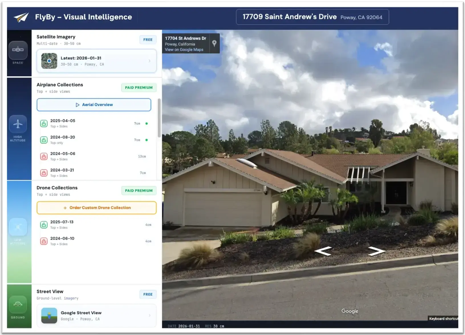
The best property decisions start with a clear view. FlyBy brings together satellite, aerial, and street-level imagery across your entire portfolio so you always have a current visual picture of every property, without leaving your desk.
 Visual Intelligence
From street level to satellite, FlyBy delivers the visual intelligence you need to stay connected to remote properties — anytime, from anywhere.
 Lifecycle Intelligence
ReplaceWise tracks component ages, expected lifetimes, and replacement costs across every property — so nothing catches you off guard.
 Capital Intelligence
CapitalScope maps acceleration potential and capital pressure across portfolios — so you can plan ahead and act (or advise) with confidence.
See more. Travel less. Communicate clearly.
Access aerial and ground-level views of any property in your portfolio without scheduling a drive-by. Stay current on conditions, identify visible concerns, and make informed decisions from your desk. When you can see a property clearly, you manage it more confidently — and your clients notice the difference.
Prioritize site visits before you ever leave the office
Use aerial imagery to assess which properties genuinely need in-person attention before committing to a drive. Reduce unnecessary travel, focus your team's time where conditions warrant it, and free up capacity for the client relationships and strategic work that move your business forward.
 Visual Intelligence
From street level to satellite, FlyBy delivers the visual intelligence you need to stay connected to remote properties — anytime, from anywhere.
Show, don't tell — and win more business doing it
FlyBy gives property managers, realtors, and real estate professionals a visual edge. Embed satellite, aerial, and street-level imagery directly into owner reports, listing presentations, and new business proposals. Spotlight Mode highlights the specific property in each image, making your materials clearer and more compelling — whether you are retaining a client or winning one.
From portfolio to visual insight in minutes
FlyBy brings multiple imagery sources together in one organized platform.
Add Your Properties
Enter properties manually or import your portfolio. FlyBy organizes them so you have a clear view of your full inventory in one place.
Access Multiple Imagery Layers
Each property is immediately accessible through satellite imagery, street-level views, and premium high-resolution aerial photography.
Review and Annotate
Examine property views, add notes, and flag items of interest. Build a documented condition history over time.
Generate Reports
Produce imagery-rich property reports ready for owner updates, inspection summaries, proposals, or internal documentation. No design work required.
Share With Stakeholders
Distribute reports to property owners, investors, or legal teams. Visual reports communicate conditions far more clearly than text alone.
Stay Current as Imagery Updates
When new aerial imagery becomes available for your properties, FlyBy notifies you so your records remain current without manual checking.
Built for the professionals who manage real property
FlyBy serves anyone who needs reliable visual access to the properties they manage, own, or represent.
Property Managers
Monitor portfolios remotely, prioritize site visits, and document conditions for owner communications.
Real Estate Professionals
Embed aerial imagery and Spotlight Mode visuals into listing presentations and buyer packages. Show properties from every angle before anyone walks through the door.
Real Estate Investors
Assess properties visually before committing to acquisition or financing decisions.
HOAs
Review community properties and common areas with a consistent visual record across the association.
Law Firms
Document property conditions at a specific point in time for evidentiary, insurance, or litigation purposes.
Property Owners
Stay informed about your assets without depending entirely on third-party reports or scheduled inspections.
What you get with FlyBy
A comprehensive visual intelligence toolkit for property professionals.
Satellite Imagery
High-resolution satellite imagery for every property in your portfolio — included on all plans. View roof conditions, lot boundaries, and surrounding context from above.
Street-Level Views
Embedded street-level views for ground-level property inspection. See facades, landscaping, parking, and neighborhood context without a site visit. Faces and license plates are automatically blurred.
Access to Purchase Premium Aerial Imagery
High-resolution aerial imagery captured from aircraft at 3–15 cm/pixel, revealing roof detail, structural features, and property boundaries from multiple angles. Available on a pay-per-use basis.
Custom Drone Collections — Coming Soon
Schedule on-demand drone flights for any property you choose — ideal for pre-acquisition due diligence, insurance documentation, and detailed condition assessment at 2.8 cm/pixel. Available on a pay-per-use basis.
Imagery Update Alerts
FlyBy notifies you the moment fresh aerial imagery is available for your properties. Stay current without having to periodically check — FlyBy watches for new imagery so you do not have to.
Portfolio Organization
Organize properties into custom portfolios for grouped analysis, reporting, and team-based management. Manage any number of properties with no property caps.
Imagery-Rich Reporting and Sharing
Generate professional reports incorporating satellite, aerial, and street-level imagery for owner communications, proposals, listing presentations, and documentation — then share directly with owners, investors, or stakeholders.
Condition Notes and Annotations
Add notes tied to specific properties and imagery sessions, building a documented condition history over time for reference, disclosure, or legal purposes.
Historical Imagery Archive
Access a deep history of property imagery going back years. Compare how a property has changed across seasons, ownership transitions, or renovation cycles — giving you the kind of long-term visual context that a single inspection never can.
Wide Coverage Area
Aerial imagery covers approximately 94% of the US population across urban and suburban areas. Rural areas with very low population density may have limited coverage.
Spotlight Mode
FlyBy uses each property's parcel boundary to visually isolate it within the image. Pixels outside the boundary are shifted toward grayscale, leaving the property itself in full color — instantly clarifying which property you are looking at, even in dense neighborhoods or complex aerial views. Ideal for client-facing reports and listing presentations.
Unlimited Users
Add team members, property managers, and stakeholders with no per-seat charges. Role-based permissions manage access levels across your organization.
Visual intelligence built with privacy in mind
FlyBy imagery is collected and used responsibly. Here is how each imagery type is designed to protect the privacy of individuals.
Satellite imagery provides wide-area context at 30–50 cm per pixel — resolutions where individual people, faces, and license plates are not identifiable. It shows neighborhoods, lot boundaries, and general property conditions — nothing more.
Airplane imagery is captured from high-altitude aircraft and is focused on property structures, rooftops, and lot features. Even at 3–15 cm/pixel, this imagery is not capable of identifying faces, reading license plates, or capturing private personal activities.
FlyBy provides access to two types of drone imagery: previously collected drone imagery available on a pay-per-use basis (similar to airplane collections), and custom drone collections that you can schedule for specific properties when you need the highest level of detail. All drone imagery is focused on property structures and features — the same professional purpose as every other imagery type in FlyBy.
Street-level imagery is sourced from public providers and is already publicly available. FlyBy presents it within the platform for property context only — viewing a property façade, entrance, and immediate surroundings as any member of the public would see from the street.
FlyBy — Common Questions
What types of imagery does FlyBy provide?
FlyBy includes satellite imagery (30–50 cm/pixel) for broad baseline context, street-level views for ground-level perspective, high-resolution aerial imagery captured from aircraft at 3–15 cm/pixel, and previously collected drone imagery on a pay-per-use basis. Custom drone collections at 2.8 cm/pixel are coming soon. Each layer serves a different purpose and can be used in combination for a more complete picture of any property.
How often is aerial imagery updated?
New aerial imagery is collected multiple times per year. FlyBy will notify you by email when updated imagery becomes available for properties in your portfolio so you do not have to check manually.
What is the coverage area for FlyBy's aerial imagery?
FlyBy's aerial imagery covers approximately 94% of the United States population across urban and suburban areas. Rural areas with very low population density may have limited coverage.
Can I access drone imagery through FlyBy?
Yes. FlyBy includes access to previously collected drone imagery on a pay-per-use basis, available alongside airplane and satellite imagery for properties where it has been collected. In addition, custom drone collections — where you schedule a drone flight for a specific property — are coming soon. These on-demand collections are ideal for pre-acquisition due diligence, insurance documentation, and any situation where you need ultra-high-resolution imagery at 2.8 cm/pixel from multiple angles.
Can FlyBy imagery be used to identify people or license plates?
No — across all imagery types. Satellite imagery at 30–50 cm/pixel provides no meaningful detail about individuals. Aircraft imagery at 3–15 cm/pixel is focused on rooftops and property structures. Even drone imagery at 2.8 cm/pixel — while highly detailed for property features — does not produce sufficient resolution to identify a specific person or read a vehicle license plate. Street-level imagery automatically blurs faces and license plates before it is made available. FlyBy is designed for property intelligence, not personal surveillance.
What can I produce and share with FlyBy?
FlyBy allows you to generate property condition reports and imagery-enriched client materials. You can share reports with owners, investors, attorneys, or other authorized parties. Permitted outputs include reports, screenshots, and derived imagery used for legitimate professional purposes involving your managed properties.
Does FlyBy replace professional property inspections?
No. FlyBy is a useful remote monitoring tool but is not a substitute for onsite professional inspections or formal property evaluations. It helps you stay informed between inspections and identify situations where a closer look may be warranted.
How does FlyBy fit with ReplaceWise and CapitalScope?
FlyBy provides the visual intelligence layer. What you see in FlyBy can inform the component tracking you manage in ReplaceWise — which tracks component ages, expected lifetimes, and replacement costs so nothing catches you off guard — and the capital planning decisions you analyze in CapitalScope, which maps acceleration potential and capital pressure across portfolios. Together, the three modules give you a more complete view of your portfolio's condition, lifecycle, and financial direction.
Is FlyBy available on mobile devices?
FlyBy is a web-based platform accessible through a browser. No additional software installation or on-site hardware is required to use the platform.
Who is FlyBy appropriate for?
FlyBy is designed for property managers, property owners, real estate investors, HOAs, law firms, and real estate professionals who have a legitimate need to monitor and document property conditions remotely. It is intended for professional use in connection with properties the user manages, owns, or has a professional relationship with.
Ready to see your portfolio from a new perspective?
Schedule a personalized demo to see how FlyBy fits your team's workflow and portfolio size.